

Dig In!
August is the second serving of Summer, the time to revisit all the enjoyments that make all the work during the rest of the year worthwhile. That might involve recreation or travel or entertainment or food or personal interests – August provides the ideal setting. Clear, sunny days and warm, inviting evenings. Is it any wonder that we look forward to this season and that people have always come to Southern California in search of a larger helping?
After Labor Day and three weeks of September, another day of equal light and darkness marks the official end of Summer (though the season takes curtain calls through Autumn in our fortunate spot on the globe). Our activities will shift to a different routine and another summer will become a memory. And memories will keep us warm in the cooler part of the year.

🎵 . . . it’s just On The Street Where You Live
Have you ever been treated like you’re just another number? In military service? (Incarceration?) By a clerk, customer rep or teller trying to nail down your true identity? Could it be because you live at an address that’s a number on a street that’s another number? Well, it wasn’t always like that in Hawthorne.
Nearly everyone in our city lived on a street that had a name until sometime between November, 1935 and July, 1938, when the City government agreed to conform to the established plan for designating streets in Los Angeles County, centered on the intersection of First- and Main Streets in (the City of) Los Angeles, the County Seat. In those days, it must have been a wrench to some of our residents – as was the conversion to conforming address numbers we endured later, in 1963-64. They gave up street names that sounded inviting (“Strawberry,” “Miramar”), patriotic (some of the Thirteen Colonies: “Massachusetts,” “Delaware“), or like personal tributes (“Wilbur,” “Shirley,” “Raymond”) and accepted numerical anonymity.
At that particular time, it was our residents of east-west-running streets who bore the brunt of the change, but the names of streets (and the streets, themselves) altered from the early years of Hawthorne and continue, on occasion, to change again.
On the Official Map of the City of Hawthorne, revised November 1, 1935, the following streets appeared,
From Inglewood Ave (east) to Prairie Ave,
Was [1935]: Is now:
Miramar St 16th St
Wallace St 118th St
Raymond Ave 120th St
Maine Ave 129th St
New Hampshire Ave 130th St
From Ramona Ave to Hawthorne Blvd,
Was: Is now: (from Grevillea Ave -)
Bettinger Ave 117th
St From Inglewood Ave to Hawthorne Blvd,
Was: Is now:
Creston Ave 131st St
Carolina Ave 132nd St
Was: Is now:
Massachusetts Ave 133rd St
Rhode Island Ave 134th St
Connecticut Ave 135th St
New York Ave 136th St
Hazelton Ave 137th St
Karlton Ave 137th Pl
Wilbur Ave 138th St
Delaware Ave 140th St
Maryland Ave 141st St
Shirley Ave 142nd St
From Hawthorne Blvd to Oxford Ave,
Was: Is now:
Kenwood Ave 119th St
From Hawthorne Blvd to Prairie Ave,
Was: Is now:
Euclid Ave 122nd St
Carolina Ave 132nd St
Massachusetts Ave 133rd St
Rhode Island Ave 134th St
Connecticut Ave 135th St
New York Ave 136th St
New Jersey Ave 137th St
Pennsylvania Ave 138th St
Delaware Ave 139th St
Maryland Ave 141st St
Shirley Ave 142nd St
From 138th St (south) to 140th St,
Was: Is now:
Fifth St Ramona Ave
Sixth St Truro Ave
Seventh St Eucalyptus Ave
From Prairie Ave to Roselle Ave
Was: Is now:
Flower Ave 132nd St
(to Rose Ave)
Strawberry Ave 135th St
Bergren Ave 139th St
You can see more changes when you visit our Museum, or read a short discussion on our website Blog, “Trading Places — Streets, Numbers and Time.”
Scarlet and Gold – the Yellow Cars and Red Cars
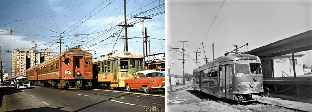
Unbelievable as it may seem, it wasn’t actually the automobile that built Southern California, it was railroads – small, short, narrow gauge local and interurban railroads reaching out from downtown Los Angeles to connect (and often, create) new places for people to live and for businesses to grow. In 1890, seven years before the tires of the first car in LA touched the pavement and fifteen years before two land developers laid out the townsite of Hawthorne, a couple of lumber- and shipping barons, who had bought up the Redondo shoreline to establish a landing where they could unload their ships, opened a railroad that ran from Second and Spring Sts (LA) to their (Redondo) wharves along the route of the future Hawthorne Blvd, through the future Hawthorne and Lawndale. The Los Angeles and Redondo Railroad moved a lot of lumber to downtown LA to feed the building boom that was changing the fields and grazing lands of Southern California to a landscape of towns and cities. It also carried passengers to and from the stops along its route.
The 1890s were a period of consolidation and modernization, as many of the small horse- and cable- and steam drawn streetcar companies and railroads were swallowed up by conglomerates converting them to electric power, beginning in 1890. The Los Angeles Consolidated Electric Railway Company (LACE) was the big fish in the pond until 1898, when Henry E. Huntington waded in. Henry was the heir apparent to his uncle, Collis P. Huntington, who operated the Southern Pacific Railroad, successor to the Central Pacific R.R. that built the western portion of the Transcontinental railroad, and also operated the state of California, with Collis’ partners Charles Crocker, Mark Hopkins and Leland Stanford. Henry had worked for his uncle in many aspects of the SP business, including buying up, consolidating and electrifying rail transit lines in the (SF) Bay Area. With a banker-partner, he bought the LACE operation in Southern California and made it the Los Angeles Railway Co., the “Yellow Cars,” working to expand and electrify the system.
When Uncle Collis died in 1900, Henry lost a boardroom battle to control SP and moved to Southern California to concentrate on business here. He began the Pacific Electric Railway, the “Red Cars,” in 1901, building a network of interurban-, rather than local routes that grew to be the world’s largest in the 1920s. Generally larger cars ran on standard gauge tracks at higher speeds between the towns and cities on an all-week, round-the-clock schedule. The system could transport a passenger as far north as San Fernando, Altadena (+the Mount Lowe excursion track) and Arrowhead Hot Springs, as far east as Redlands, Corona and Santa Ana, as far south as Balboa, Long Beach and Point Fermin (San Pedro) and as far west as Canoga Park, the Santa Monica Pier and Clifton-by-the-Sea (Redondo Beach). Huntington paired up the PE with some of his LA Railway routes by installing double gauge track, including the route through Hawthorne.
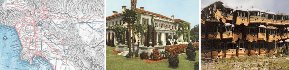
The “Yellow Cars” were electrified in newborn Hawthorne in 1905 and became the principal transportation for new residents whose work or business or personal affairs took them beyond the borders of the little town. A few years later, a rider could take a “Yellow Car” from Hawthorne to Eagle Rock – the longest streetcar route in the US, at the time. In 1911, the “Great Merger” brought control of all the electric railway lines under Southern Pacific RR. The LA Rwy “Yellow Cars” route from the north terminated at Hawthorne Blvd and Broadway. The east-west Pacific Electric line “Red Cars” could be boarded at a stop – later a station – just a few steps to the south. The distinctive color scheme of each service was recognized far and wide throughout our region.
There’s truth in the legend that the big American car manufacturers colluded with one another and with municipalities to replace streetcars with buses, but ridership was beginning to decline as early as the 1920s when the effects of personal car ownership began to be felt. Buses were cheaper to operate and were not tied by tracks to a fixed, invariable route. As the quantity of passengers being carried diminished, streetcar lines dropped trips from their schedules and eventually closed sections of routes where they sustained losses. The automobile dominated the roadways by the 1950s as the Federal Aid Highway Act of 1956 generated freeways in Southern California and Interstates across the country. The “Yellow Cars’” last trip on the ‘5’ Line to Hawthorne was on May 22, 1955. “Red Cars” were replaced by diesel buses by 1963.
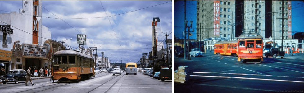
The streetcar lines did a fair share of the work in establishing Hawthorne and growing her into a developed city. Though there are only a few of us now who can remember the sight of a “Yellow Car” rolling up to the bumpers on Broadway or a “Red Car” sliding across Hawthorne Blvd behind the lowered arms of the crossing gate, an affection for this way of travel has long inspired people to preserve, restore and operate the old equipment within fairly easy reach of our busy cities. Some of us can literally relive the sound of doors clattering closed, the first lurch of the car, the screeching wheels and growling armatures, the clanging bell and the crackling contacts on the wires overhead.
For those who were convinced that rail transit remained a valid solution for part of the transportation needs of Southern California, LA Metro (Los Angeles County Metropolitan Transit Authority) has built and operates 109 miles of railway to connect us to our destinations. A track crossing Hawthorne, the ‘C’ (formerly Green-) Line Extension to Torrance is being planned, with operation starting in 2030 – 2033.
(The Calendar of Coming Events will now be included in the Events feature on the Website).